SMD and Beam Go Deeper for AI-Driven Autonomous Offshore Wind Inspections
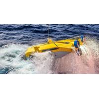
intelligence (AI)-driven system to improve its operational scope and offshore wind farm servicing.Beam’s SubSLAM system, running on Pathfinder software, will be added to the ROV, enabling AI-driven autonomous piloting in deeper, harsher waters.By combining SubSLAM’s localization, AI and mapping technology with Quantum EV’s high-current performance, vital progress will be made towards improving the efficiency of offshore wind farm maintenance, according to Beam.“We are delighted to collaborate with Beam, a company that shares our future focus and passion for innovation.“SubSLAM&rsquo
Fugro and PlanBlue Partner to Advance Habitat Mapping Technology
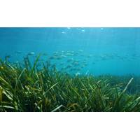
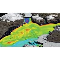
Fugro and PlanBlue are teaming up to advance habitat mapping technology as the companies work to integrate new mapping technology and digital solutions within Fugro's existing systems.The partners say their aim is to enhance and broaden Fugro's hydrographic solutions by incorporating cutting-edge technology such as advanced imaging and AI-based processing and deploying it across different platforms like remote and autonomous underwater vehicles. This collaboration targets the improvement of habitat mapping solutions, systematically studying and documenting the characteristics and distribution
Discovery: Historic Shipwreck Found in Lake Huron
Huron with Ocean Exploration Trust, the undersea exploration and education organization founded by famed explorer Dr. Robert Ballard, who has explored nearly every corner of the planet. Ocean Exploration Trust brought a team of world-renowned hydrographers and the latest innovation in underwater mapping technology to Michigan, including an autonomous surface vehicle named BEN (Bathymetric Explorer and Navigator)."Our team is proud to partner with the Office of National Marine Sanctuaries to bring innovative technology and expedition expertise to map the Great Lakes," said Ballard. "Ironton
AI Guides Rapid Data-Driven Exploration of Changing Underwater Habitats
seafloor imagery was acquired with an underwater vehicle “Ae2000f” using high-altitude 3D visual mapping cameras at underwater sites between 680 and 780 meters depth. The international team deployed multiple AUVs, developed by the University of Tokyo, which were equipped with 3D visual mapping technology developed jointly by the University of Sydney, University of Southampton, and the University of Tokyo and the Kyushu Institute of Technology as part of an international collaboration.The conversion of the initial wide area survey imagery into three dimensional seafloor maps and habitat type
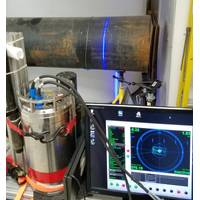
Underwater Laser Mapping on the Move
, UK. have completed tests to integrate Newton Labs’ underwater laser scanners with Sonardyne’s acoustically-aided inertial navigation system for underwater vehicles, SPRINT-Mapper. The companies say the milestone paves the way for greater adoption by industry of mobile laser mapping technology to survey seafloor sites and subsea structures, and eliminates many of the challenges currently faced by users when attempting to configure advanced sensor technologies from different vendors prior to mobilizing equipment offshore. Newton and Sonardyne entered into a formal collaborat
Kongsberg's Acoustic Scientific Research for RSS Sir David Attenborough
polar seagoing science platform, and for provision of logistical support for land-based polar science. The new ship will enable scientists to explore and undertake science in new areas of the Antarctic and Arctic seas, supported by an extensive, integrated KONGSBERG scientific research and mapping technology package, including: EM 122 Deep water multibeam system EM 712 Medium depth multibeam system TOPAS PS 18 Sub bottom profiler EA 640 Scientific echo sounder EK 80 Biological multi-frequency echo sounder ME 70 Biological multibeam echo sounder MS 70 Biological
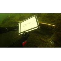
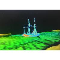
530-year-old Shipwreck Surveyed
. The combination of the SROV and the photogrammetry delivers amazing results in commercial contexts. All data collected on Gribshunden will serve as a foundation for planning future excavations. Used this year was research vessel Svanen, a 10-meter-long catamaran equipped with the mapping technology and expertise from MMT, and financed by the main owner of MMT, Carl Douglas, to support coastal archeology and technology development. The regional museums Blekinge museum and Kalmar läns museum are local partners in the Gribshunden excavations
Contract Award for the Longest HVDC Route Survey
and Iceland. MMT´s CEO Stefan Eliasson commented upon the contract award, “This is a very exciting project for us at MMT since we are taking the Surveyor Interceptor ROV out on its first HVDC route survey and in deep water. We are delighted for ASC’s confidence in our new mapping technology and can´t wait to be part of the early assessment of this historical project.” mmt.se
MMT Restructures, Hires New Management
, CEO, said, “We have the best team of competent coworkers, we have a game-changing survey ROV on the market and returning clients. We will prove for the industry that we are a company that is beneficial to work with and whom deliver the highest resolution survey data and the latest marine mapping technology – and this time with an even more cost efficient, reliable and innovative approach.”