Seabed Geosolutions Wins Brazil Survey Work
Fugro said its joint venture with CGG has secured a contract from Petrobras for a 3D ocean bottom node (OBN) survey in the Brazilian Santos Basin.
The seven month contract awarded to the survey firms’ joint venture Seabed Geosolutions is valued at around $90 million and is scheduled to commence at the end of the fourth quarter of 2017 or early 2018, Fugro said.
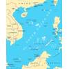
According to Seabed Geosolutions CEO, Stephan Midenet, the OBN survey is the “industry’s largest ever” and will span more than 1,600 square kilometers.
Midenet added that Seabed Geosolutions’ new Manta technology will be deployed for the project, “delivering a breakthrough in efficiency of ocean bottom surveys.”
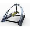
Manta, engineered as a cost effective alternative to a wide-azimuth (WAZ) streamer survey, is a single four-component (4-C) ocean bottom node technology designed to work in water depths up to 3,000 meters. The fully autonomous, modular system delivers geophysical illumination with flexibility for dense source grid, full-azimuth and long-offset surveys, according to the developer.
Manta’s long-endurance, modular node combines contemporary micro-components with recent advances in rechargeable power-dense battery technology. 4-C multicomponent sensor incorporates three omnidirectional geophones and a hydrophone. An integrated inclinometer continually records the orientation of the node once it is positioned on the seafloor.
Manta’s long-endurance, modular node combines contemporary micro-components with recent advances in rechargeable power-dense battery technology. 4-C multicomponent sensor incorporates three omnidirectional geophones and a hydrophone. An integrated inclinometer continually records the orientation of the node once it is positioned on the seafloor.
“We are confident that our crew, in close cooperation with Petrobras, will be setting new safety, data quality and efficiency standards for deep-water nodal surveys allowing for cost effective acquisition in both large scale and 4D projects,” Midenet said.
- Manta General Specifications
Physical
Weight in air: 18.3 kg
Weight in water: 10 kg
Dimensions: 350 mm wide x 350 mm depth
Height: 130 mm
Operational/Environment
Max operating depth: 3000 m
Operating temperature:-5°C to 40°C
Battery duration: 75+ days
Battery recharge time: 12.5% / hour
Sensor
Hydrophone: High Tech Industries HTI-96–Min
Geophone: Omnidirectional, 14Hz, with 0.7 damping
Inclinometer: 3 Axis MEMS calibrated horizontal axes, range +/- 90 deg @ 1 deg, +/- 0.5 deg
Data Recording System
Channels recorded: 4
Sample rates: 1 ms, 2 ms
µSD card: 64 GB, 120 days, 2 ms sampling
ADC resolution: 24-bit
Anti-aliasing filter: Linear or Minimum phase
Time Synchronization
GPS derived Rubidium IEEE 1588 Grandmaster reference
Sync latency: +/- 100ns, Jitter +/- 15ns
Clock Stability (OXCO)
Clock drift: 2E-8
Residual error after correction: Less than 1 ms